Meet Christos Iliadis
Email: c.iliadis2@newcastle.ac.uk
Host: Newcastle University
Title of research project: Improved flood modelling for the built environment and infrastructure – Achieving urban flood resilience through hydrodynamic models
Supervisors: Dr. Vassilis Glenis & Prof Chris G. Kilsby

The extent and severity of the damage caused by urban floods is a product of both the intensity and duration of the rainfall and its interaction with the complex flowpaths of a city, on the surface and below ground. There is a great need to understand and improve how hydrodynamic models can represent urban features and be used to manage flood risk in the built environment. The current methods are currently blocked by the lack of a realistic approach to represent buildings in hydraulic models. Resilience Flood Protection planning in cities is the major topic due to climate change and the increase of the urbanization. This project will focus on urban flood modelling, the realistic representation of urban features in flood models, the reduction of damages from floods, new methods to increase the resilience of buildings, the path to blue-green infrastructure, and the definition of the water flow path in urban areas.
The main aim is to understand and improve how hydrodynamic models can represent urban features and be used to manage flood risk in the built environment.
The outcomes will be:
- The most appropriate and realistic representation of urban features into the hydrodynamic models.
- The Resilience Protection of buildings against flooding, and the reduction of damage inside them.
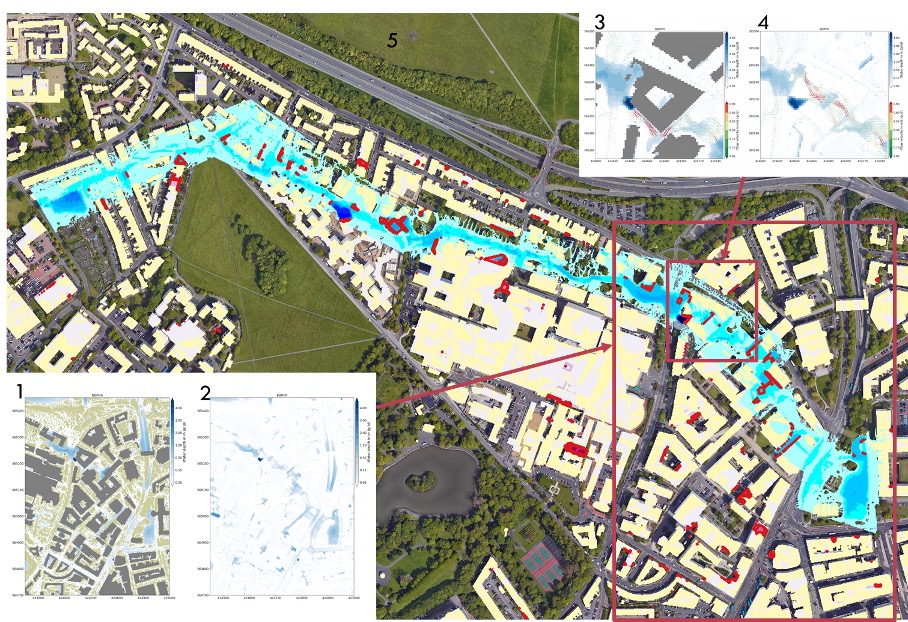
The image shows 5 flood maps in central Newcastle upon Tyne derived from two different approaches for the representation of urban features: a) the Building Block (BB) approach and b) the ‘Stubby Building’ (SB) approach. The BB approach is shown in figure 1 and the SB approach is shown in figure 2. The differences between the two approaches are evident when zooming in on the Merz Court Building (Newcastle University) as shown in figures 3 (BB) and 4 (SB). The results from the SB approach show that the Merz Court Building is flooded, and this is not correct. Figure 5 shows the flow paths using the SB approach and the flooded building are coloured in red.